Thursday, March 22, 2012

# 11 Mt Washington (6288’ ) March 22,2012


# 11 Mt Washington (6288’) , March 22, 2012


03/22/2012 (Thursday) .  Up  Ammonoosic trail to the Lake of the Clouds Hut (closed) then up Crawford Path down Edmond and back the same way.  Elevation gain: 3994’  Book time:  8:34,  My hike time 10:30 hrs;  (0730 to 1930 – 1.5 on top),  ratio to book: near 1.22 (that good for me).  Ammanoosaic is the steepest, and I think the more scenic of the two trails up from the Cog railway side of Washington. The other being Jewel.
                The weather was unbelievably warm for 
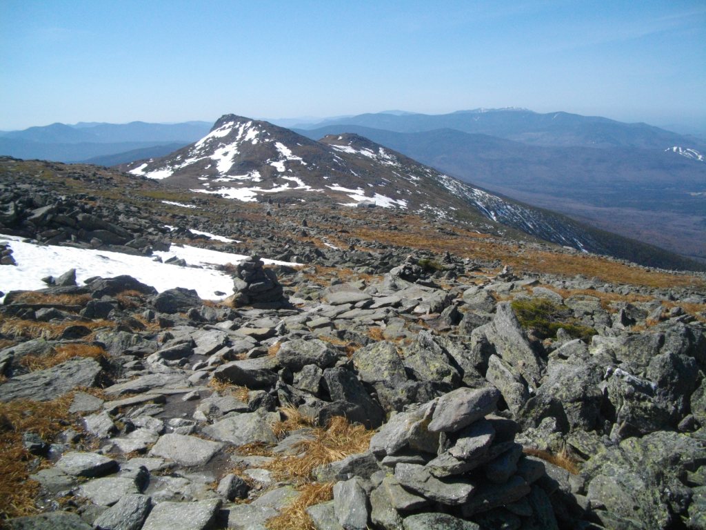
this time of year and there was barely any snow above the Lake of the clouds other than  one short snowfield that was still fairly deep.  I had dropped my snowshoes at the hut so I post holed my way across the field.  Going up from the hut to the summit I could see why its called the rock pile.  The upper part of Washington really is only a big pile of rocks and boulders.   Some of the trail had water running down it , even on the dry sections you could hear the water running under the rocks from all the melting ice below the surface.  Reaching the top was a bit anti climatic.  The trail from the hut up is not particularly steep or difficult (though long). The big thing about Washington is it's infamous weather.  And,  I was hiking up on what could well be the best weather it's ever had in March.  It would almost have been a shame if I'd hiked it the day before because it would have counted as a winter hike and it really shouldn't.

 The most significant part of this hike was not the summit but a very tough river crossing going down.  Because of all the melting snow and Ice on this extraordinary warm March day, a river that I had easily rock hoped across on the way up had turned into a roaring rapid by the time I returned to it on the way down.    There was no way to cross without  getting calf deep in the sweeping water On top of that just below the only hopeful place to cross was a steep water fall.  If I had tried to wade across and lost my footing  I was sure to get swept over the falls.  One option would be to backtrack and go down the Jewel  trail but that would have added hours to a trip that was already running late. Luckily I had a 25 ft length of webbing with me. I tied one end  to a tree a bit up stream of were I wanted to cross and waded across with a firm grip on the other end of the line. ( I guess you could call this a lateral repel) . This worked out with no problem other then getting drenched from the knees down and having to leave the line behind.  I felt pretty good about overcoming this obstacle,  much more than finally submitting Washington.


Pictures:


coming up on lake of clouds hut (close)


first real view of Washington


top of the Cog rails


Small snow field above the hut (see my post hole tracks)


next few pictures are of a very hard river crossing that
 was much easier on the way up before the snow started melrting.


Line I tied to a tree to do a lateral repel.
view up steam from thge crossing

frozen falls above the crossing

Steep falls below the crossing


GO BACK TO THE INDEX.  

GO TO THE NEXT HIKE

GO TO THE PREVIOUS HIKE

Friday, March 16, 2012


# 9 & #10 Pierce(4310’), Eisenhower (4780’), March 16, 2012:
"The Spuce Trap Hike:
 03/16/2012 (Friday) ,  Up  Crawford Path down Edmonds Path plus 3 miles on Closed Clinton Rd.  El gain:  3411, max El change:  2871’,  Book time: 8:59 (includes 2 hrs for Clinton rd).    My time 9:50 hrs;  (0730 to 1630 – 0.5 on top),  ratio to book: near 1.0  (this can’t be right! I logged this 14 days later so some  times may not be right.

This logged 14 days later so may not be accurate. It was lightley snowing at the start with a heavy low fog.  I started from the parking lot at the Crawford Connection TH just off Clinton Rd , which is closed from that point.  Then onto Crawford Trail (CT).  Started with microspikes and kept them on just to where Webster Cliff Trail (WCT) meets CT.  Pierce is less than 500 ft back up WCT.  When I first broke out of the trees, both Ike and Mt Washington were visible but by the time I got my camera out, the overcast (undercast?, fog? , low clouds?)  had risen and obscured the views. I put my new “MS flash 25” snowshoes on before going up the short distance to Pierce and kept them on for most of the hike. The trail was well packed going up Pierce marked with many postholes on the sides of the track.  I think I only added 2  post holes to the trail.  Above the trees it was about 2-6 ft of snow but was in general wind packed but shoes were still needed above the tree line. The traverse over to Eisenhower was fairly easy.  Very little to no wind and 10-30 degrees.  I could find the trail by faint outlines of old post holes and by following rabbit tracks, they seem to like to traverse along the trail as well. The south side of Eisenhower was fairly bare of snow so I had to remove the snow shoes part way up.  I bare boot the remainder of the way up. I had read that Eisenhower is actually one of the easier mountains and the easiest presidential but it turns out that that’s on the north side which has many switchbacks.  This section was fairly steep. On top is the largest cairn I’ve come across yet (10 + ft ?) . There were great views from Ike because the “undercast” had settled down below most of the peaks making it seem like an ocean of islands rather than mountains. It reminded me of Vietnam during the monsoon season when the hills become islands.  At this point I was feeling pretty good about myself summiting two Presi’s in the winter in pretty good time and not exhausted.  This was about to change!

Walking down the North Side of Ike the snow was getting deeper but it was still fairly well packed on the trail. I was still bare booting because I couldn’t decide if I’d needed snow shows or could get along on spikes. Half way down between the summit of Ike and the ridge  I stepped a bit off the trail and went in deep up almost to my waist with both feet.  Looking around and seeing just the top tips of spruce trees poking out of the snow nearby I realized that I had falling into what are called “spruce traps”.  This is where the snow keeps accumulating around and on top of the smaller alpine spruce tree but can’t accumulate below the tree so that you get large air pocket underneath its limbs. The unsuspecting hiker walking over or too close then falls into the unpacked snow and branches with nothing to support his weight except the light limbs of the trees.  I tried to pull myself back up on the packed snow but it just kept collapsing in on me so that I had nothing to support myself and one of my boots was stuck in the branches.  Finally by pulling off my pack and using it and my poles (crossed and horizontal) I managed to pull one leg up and more or less support it above the hole and tried to use it to brace myself and free the other leg.  I was also trying to loosen up the snow above my stuck foot with my poles, but no matter what I did I couldn’t free my other foot.   I started envisioning being permanently stuck there and subject to exposure when the sun set or the weather changed.  Did I mention that I hadn’t seen even one other hike on either mountain so the chance of someone coming by to help was nil.  Eventually I was able to dig out the snow down to the top of my boot and loosen the lace and the gator so that I could free my foot from my boot.  Now at least if I had to I could get down with just one boot (possibly fashion a shoe out of a windbreaker and duct tape ).  The gator was luckily still tied to the boot so I used that to hold onto it so that the boot didn’t fall further down into the tree. I still couldn’t pull out the boot and the gator was starting to tear. I think what was going on was that the crampon ridge on the back of the boot was stuck under a strong spruce branch. I was finally able to dig out the boot while lying on my stomach and shoveling out the snow with my hands.   This all only took about 20 minutes but seemed like forever for me and was sapping away a lot of strength.
The remainder of the hike down Edmonds was also tough with me postholing with snowshoes many times until I was well under the foliage.  The problem is that Clinton road is closed in the winter so that Edmonds path does not get a lot of use and was not broken out.  The highlight of the hike down was a lot moosetracks along the path, but I still never saw a moose.


Pictures :


blow down

Just breaking out into the Alpine area below Pierce


Only set of tracks are mine

Washington trying to breakthrough

On top of Pierce (Clinton)
forgot to take a pic at the top so I had to backtrack a bit.
I think that's Washington near my head.


Eisenhower - now you don't see her...

Now you do - 5 minutes later.

clouds rolling back in.


Eisenhower from the South side
Islands poking through the clouds.


Beathtaking views.


half way up south side of Ike.


Huge Cairn on top of Eisenhower in sight.

Following are a few pictures from the top:


#10 Eisenhower

trail heading down N. side of Ike
- before I got stuck in the spruce trap


Rainbow in the valley, photo didnt catch it that good.


Now they tell me!! came across this sign on the way down.

Many moose tracks on the trail down.


GO BACK TO THE INDEX.  

GO TO THE NEXT HIKE
GO TO THE PREVIOUS HIKE