#43 & # 44 The Hancocks 12/22/12
#43 & # 44 Mt. Hancock (4040') & South Hancock (4319) 12/21 - 12/22.
Trip Stats; 9.8 miles, 2940 ft elevation gain/loss, AMC book time: 6:20. My hiking time ~10.5 hours (2330 - 0300, 0800-1500 on 12/21 - 12/22/) with a 4 hour bivouac. My time ratio to book: 1. but, I'm not sure if AMC book time even means anything in the winter. Either way I don't really care.
Trip report: This turned out to be a bit wordy. Just jump down to the pictures and captions for the short story.
I wasn't planning on hiking again until January but with recent reports of snow finally covering the ice reported on most of the trails, and since Obama gave me Monday off, I figured I try and sneak a hike in before the end of the year. This was my first official winter hike for this season. It is also the first time I've set up a tent and camped out on the trail. Driving up from Rhode Island, hiking, and driving back all in the same day is really starting to get tough. So, the plan was to drive up Friday night and either sleep at the National Forest Hancock campground on the Kancamagus (open all year ) and get an early start from there (as I did for the Owl’s Head hike). Or, weather permitting, hiking in with a tent and sleeping bag by headlamp as far as I felt comfortable, set up camp by the trail, get some sleep and leave the tent, bag and some gear at the site to pick up on the way back. The Hancocks are a perfect hike for this plan. It’s a loop hike but doesn’t start the loop until about 3 hours in (my speed) and the first section before the loop is fairly level so the extra weight isn’t that much of a concern. Arriving in Lincoln NH the weather was clear with nearly a full moon so I went for the camping off trail option. I first pulled in the Lincoln Woods trail head lot to gear up at the restrooms there. I actually didn’t start hiking until after 11pm Friday. The trail was easy to follow by headlamp and moonlight. There was a solid base of frozen snow with 1-2 inches of recent snow and covered boot tracks 1-2 days old most of the way. There was the occasional frozen deep post hole (boot prints) that showed that the snow had been recently soft then frozen over. There were quite a few small step-over stream crossings and a few actual river crossing that were a bit difficult in the dark without tracks to follow and no traction ( I had mistakenly chosen to bare boot this first section of the hike). At one point I slipped on an icy rock and got both boots wet. My boots are well waterproofed and my feet stayed dry and comfortable. On the way back the next day I did have microspikes on and the crossings were actually all easy rock hops. I was hoping to get all the way to the loop junction but about half an hour before it I was getting pretty tired and found a good spot to make camp right near the trail. I had read on some sites were people think that you have to camp at least 200 ft off trail throughout the entire WM forest. This isn’t completely true. In the areas declared “a wilderness” and in specific “protected areas” (which include all alpine areas) this is true but otherwise you can camp right near the trail (right on the trail, I guess, if you’re not afraid of being run over by a moose). Anyway I tramped the snow as best as I could to make a level area and pitched my tiny one man ten, covered my pack and gear with a poncho and slid into my bag and liner on top of the foam mat. This was the first chance I’ve had to use this tent that my wife bought for me on my birthday (as well as my pack) to use on the Bonds hike. However on that hike I ended up sleeping in a shelter. The tent is free standing and ultra light (less than 2 lbs with poles) and packs up into a very small pouch (see pics). It worked out pretty good. Not enough room for me and my gear though so I store my pack and gear right outside under a poncho. My bag is only rated at 20 degrees F, but I had just bought a liner that is suppose to lower the rating by another 20-25 degrees so the combined rating should be near zero. The liner is really nothing more than a thin flannel full body condom. I find it hard to believe that it does what is claimed. I was fairly comfortable (but not warm by any definition) after swapping my lighter sweaty techwick shirt with a heavier dry one. For some reason, my feet were cold all night and I should have put on a second pair of heavy socks but didn’t want to climb out of my cocoon. The high point of the trip is the downhill from S. Hancock. The trail down from S. Hancock is perfect for butt sliding (I believe the technical term is glissading). It’s almost as if it is made that way by design. It’s like a bob sled slalom course through the trees with just enough turns to manage your speed. I did a 600 vertical ft continual butt slide run. Then several others in between more gradual slopes were I had to push off or actually walk for a while. I’m glad I had on my waterproof nylon pants and had changed back to microspikes which helped me control my speed. I tried to butt slide down a section on Jackson last year with my snowshoes on and ended up in a tangled twisted mess. It was evident from the smooth trail path that the 4 hikers that had passed me between the peaks had also glissaded down. I had forgotten about it, but half way down I recalled reading last year about how great this section is for a fast and relatively safe butt slide down. I made it back down the 0.5 miles to the loop junction in less than 20 minutes. vs. the over two hours it took me to do the 0.7 miles up to Hancock from that spot. The rest of the hike was an easy walk out with a short stop to pack up my tent and pick up the rest of my gear. I think this hike would be a lot harder in the summer and especially several weeks ago when it was probably all ice.
44 down and 4 to go! Waumbek, Moriah, Isolation, and Madison. I’m hoping to do Waumbek & Moriah in a two day trip staying at the Shapleigh bunk house at the AMC Highland center. But, if I can catch some warmer weather , I may consider camping off trail part way up Moriah the second day. I’m really glad to see the snow back, disregarding the temperature, most of the trails are actually easier with enough snow to cover any ice and all the knee jerking rocks and steps on the way down.

screen shot of map amc guide on line

My campsite just after getting up.

Typical view on the trail to the base of Hancock

You can see the sun starting to cover the peak.
Seemed like forever to get to the sun line.

The junction of the loop to both Hancocks. I went left.
The sun bathing the peaks but not me.

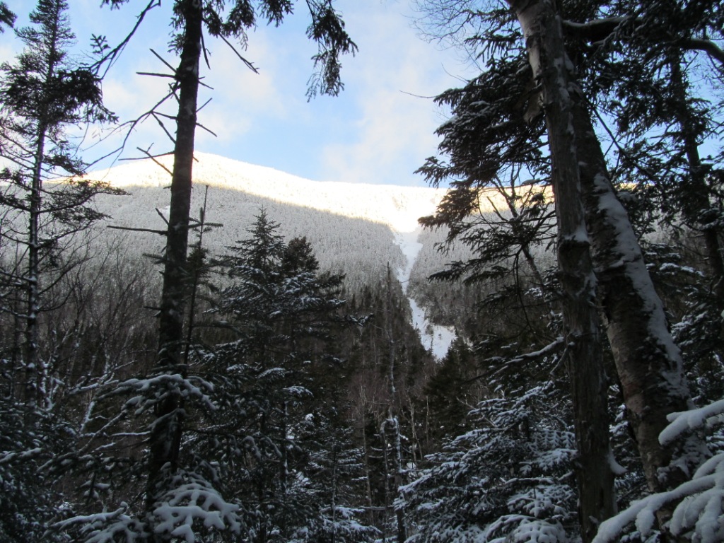
Zoom in on the slide down Hancock.
I was concerned that the trail may be up the slide,
which looked icy, even though I hadnt read that it was. It wasn't

Snow field at the low point just before the steep ascent up Hancock -
I was tempted to build a snowman.

Signs of a broken out trail got lighter and lighter with elevation.

a few peaks out on the way up

I was trying to capture the steepness of the trail here
but it doesnt really show.

Trees starting to get shorter and allowing a few views.
- always a good sign that your nearing the top


#43 Mt Hancock.
If you can't tell by my face, the last section was a bit tough - they always are.
I'm actually very happy on the inside.

Open outlook 50 ft from the peak,
A few pictures from the outlook follow:


#44 South Hancock - looks like I'm taking a nap but I just blinked

I wore my snow shoes for the 1.4 miles between Hancock and South Hancock.
The snow was a bit deeper with some small drifts but I didn’t really need the shoes.

Back at the loop junction after a great butt slide most of the way down from S. Hancock

back at my camping site

took only 10 minutes to break camp and pack up the tent
small bag on the upper right is the 2 lb tent.

Not looking forward to carrying my full pack back. When I got home I weighed it and was surprised that it was up to 42 pounds (without water). Some of that is from a frozen fleece jackets

The trail out had pleasant views of streams still flowing that will be covered over soon
.On the way in I could only hear them.

one of the signs that designate protected areas

This sign shows that you are leaving the protected area
with no restriction on where you camp (just leave no trace)


A lot of trees bent over like this across the trail from earlier heavy snow,
I knocked the frozen snow off a few but they remained frozen in place.


Back at the trailhead parking lot (also a scenic vista viewing area) at the extreme hairpin turn on the Kanc. There is a short trail from the far right corner that leads to a place to cross the Kanc
and start the hike. I t was nice to finish early enough that I could enjoy the views leaving the Whites.
GO BACK TO THE INDEX.
GO TO THE NEXT HIKE (Waumbek)
GO TO THE PREVIOUS HIKE (Whiteface/Passaconaway)
posted by 1SlowHiker @ 9:05 AM
0 Comments
![]()
