#34 & 35: TRIPYRAMIDS, Nov 1, 2012
#34 & #35 TRIPYRAMIDS, NOV, 1, 2012
#34 North
Tripyramid (4160’), #35 Middle Tripyramid (4120).
With Hurricane Sandy gone I was able to do a
Birthday Hike after all. After reading Chris Dailey’s Tripyramid trip report I was
tempted into attacking the Tripyramids. After this hike, if asked what was my
toughest hike so far? “Slide on N. Trypyramid”. What was my most dangerous hike so far? “Slide
on N. Trypyramid”. What was my favorite
hike so far? “Slide on N. Trypyramids”.
This hike was a loop from the Livemore Trailhead near Waterville
Valley up the Livermore trail to the Tripyramids trail up a very steep rock
slide to North Tripyramid to Middle Tripyramid to South Tripyramid (my # 35)
down another less steep slide and back onto the Livemore trail then back to the
trail head. Total distance is 11.1
miles. AMC book time is 7:10, my total
time was about 9 hrs (08:45-17:45). No real long stops many many 2-5 minute stops up the North Slide.
There was 1 or 2
cars at the trailhead. When I got there . Another hiker, Casey from Salem N.H.
showed up just after me. The 1st 2.6 miles is an almost
level back woods road hike to a junction with
the portion of the Tripyramid
trail that I would return on from S. Tripyramid. Casey had caught up to me at this point and of
course soon disappeared from sight ahead of me as the trail got steeper (my speed is inversely proportional to the
grade). The trail then splits again with
the start of the Tripyramids trail to the right and the Livermore continuing
left connecting to the Scaur Ridge trail that connects to the Pine Bend Brook
trail which is an alternate longer but less steep approach to North Tripyramids.
The Tripyramid trail to the right
crosses Avalanche River then runs parallel to the river until it reaches the base
of the north slide . Part of the trail
was almost a river itself and the rest was difficult to follow, covered with
leaves and no blazes in sight. I’m not
sure if I actually followed most of the trail but as long as I kept the river
to my left within earshot, I knew I’d run into the slide part of the trail. The slide started off fairly narrow, not too
steep, but it kept getting wider and steeper. According
to AMC this slide is extremely steep and climbs 1200 feet over a distance of ½ a
mile. After about 10 minutes on the
slide, I ran into Casey working his way
back down the slide. He said he was turning back and said something about it being
insane or suicidal to continue and suggested I turn back too. I of course continued and very slowly worked
my way up. I have to admit that this
slide was extremely tough and challenging but taking one step and hand grab at
a time and carefully planning my approach it was manageable. However, with it being so steep I needed to
stop almost every 50 feet of elevation for 2-3 minutes to catch my breath and
let my heart rate settle down. I found
that the sides of the slide had small trees and roots for hand grabs but also were
wetter and had a light coat of moss or lichens in spots making it more
slippery. The center was drier making it less slippery but had less hand grabs
and was more dangerous if you did slip because there wasn’t anything to grab or
stop you. Luckily I had worn my winter
boots for this hike and had I better traction than my worn-down summer boots
that I had worn on last week’s Kinsman hike. It took me almost 2 hours to work my way up to
the cairn at the top of this ½ mile slide.
I did have some pretty good views
north and west during my many breaks but the sun never really broke through the
hazy day. Just after the top of the slide, the trail continues up through the
woods and meets Pine Brook trail just below the peak. Just as I got to this junction I met Casey
again coming up from the Pine Brook trail. He had gone all the way back to the Livemore
/Tripyramid junction and came up the longer Scaur Ridge and Pine Bend trails route and hiked almost 2
miles in the time it took me to a little over 0.5 The viewless N. Peak seemed less than an
accomplishment then reaching the cairn at the top of the slide and I even
forgot to take a picture. I hiked down the col between the north and middle
peaks but of course fell behind again on short ascent to the Middle peak. The
hike from the North to Middle to South Peak is fairly easy but was littered
with a lot of blow-downs and small braches from Hurricane Sandy. The slide down
the South Slide was fairly easy and uneventful. It would have been an easier climb than the north
slide but I would not want to have to gone down the steeper north Slide. I found a hiking stick in the middle of the
slide which I assume Belonged to Casey. From the base of the north slide back to the
junction with Livermore was also easy and also littered with damage from Sandy.
There were two fairly difficult river crossings
on the way back. The first, which I could not identify on my map, was a roaring river (see pics) dumping into
Slide Brook . The second was Avalanche Brook
just before the Livermore junction. This one was much calmer but I couldn’t figure
out a good rock hopping route and ended up balancing my way across a fallen
tree (see pics). Once across it was an easy 2.6 mile fast walk
back to my truck. Casey, if somehow your
reading this, email me if you want your hiking stick back
(clementsmw@verizon.net)
Pictures:
My camera lens was smudged and foggy so many pictures did not come out. Many that I did keep are still blurry.

beginning of the north slide.

northern view from the slide, sun trying to clear

lower section had a lot of hand grabs.

This shot captures the steepness of this slide.

first blaze I saw all day
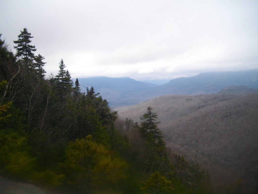
Western view from the slide

More of the slide before it widens

clouds trying to clear from Osceloa?

Looking up the endless slide

Waterville Valley slopes

Cairn half way up

Slabs on side of upper part of slide

Many stops to catch my breath and take pictures.

The end is in sight
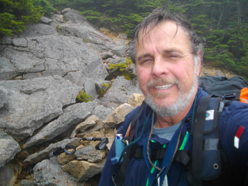
Finally at the top of the slide -
I was clean shaven when I started up it -lol

foggy short hike from the slide to the peak

Junction with Pine brook trail where I met Casey again.

No views from N. Pyramid

Middle Pyramid Peak (#35)

Hurricane Sandy debri

more trail obstacles from Sandy
in col between M. and S. peaks

Tiny cairn at S. Tripyramid

Looking down the South Slide

weather trying to clear again

Almost a view to southeast from South Slide.

Looking back up the south slide.

Waterville slopes bareley visible to the right

Not really clear but I did avoid any rain.

From Sandy?

Many step overs.

Many branched falls. The hardest to get through.

Obstacle course or hurdles.

Road Block !

First hard crossing

I'm not going across that tree.

This is where I crossed. Not too bad, but rocks where slippery.

Sandy or Irene?

This is tree I used to cross Avalance River

Could have actually waded that one.

Back at the trail head - just after dusk.
GO BACK TO THE INDEX.
GO TO THE NEXT HIKE
GO TO THE PREVIOUS HIKE
posted by 1SlowHiker @ 7:28 AM
1 Comments
![]()
