Friday, November 23, 2012

# 39 Carrigain Nov 23 2012

Mt Carrigain 4700 ft (#39/48)Friday Nov 23, 2012

From Signal Ridge trail-head via Signal Ridge trail; 10.0 miles. Elevation gain & loss 3642 ft.
AMC book time:  4:14 up,  2:35 down, total 6:49.
My moving time (excluding breaks over 5 minutes)  5:10 up:     3:05 down:       total:  8:15
     Ratios to book time about 1.2 , actually not bad for me. I thought  going up was much worse, especially after finding that someone that got to the top just after me started over two hours after me.

  Not sure why, but it was a pretty hard hike up for me. But it wasn't particularly steep or difficult looking pretty good elevation gain though for 1 peak.  Maybe it was the Thanksgiving dinner the day before. I got a later start then I had planned startec at 0645.  Had some problems finding Sawyer River Rd.  I had plugged the coordinates for the trailhead into my cars GPS and evidentley it didn't know about Sawyer River road and it kept trying to send me in from Rt 302 to do a  beeline bushwack.  I had planned to hike this weekend, but the weather Sat & Sun was snow and colder. Friday was a perfect day.  Not sure how warm it got (50?) but I was down to one thin layer after 10 am.
Carrigain is a great hike and most noted for its great 360 degrees views from the firetower above its peak.  Many people save it for a celebration of the last of their 48 4,00 footers. I was going to save it or Madison for my last, but when I saw that the Saywer River road was open (it had been closed for repairs since Irene) and would probably close for the winter by December 1st, I figured I grab her now and save myself 4 miles of road hike and 500 ft of elevation change.
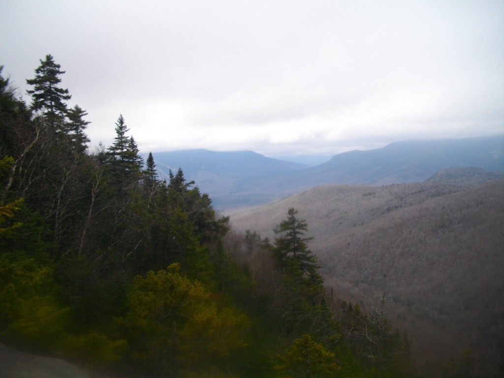
  The trail is almost a level "walk through the woods" for the the first half through bare hardwood trees then ascends at a fairly uniform rate along the east side of Signal Ridge through fir that occasionlly offer views  to the east, Voss peak in particular which is on the NE 100 list and an interesting looking mountain (see pics) .
I don't have the words to describe how great the views from the tower were, so I took  pictures at 8 compass points and loaded them below.  The trip down was surprisingley easy and fast for me. 

Pictures:
New camera since I broke my old one last trip. This one is much heavier but has a 12X optical Zoom.

Only a few small signs of ice on the lower trails

Lower trails are easy walk through the woods.
First view of the ridge .

Why?  (I think maybe to divert people from an old trail )

Only significant crossing - easy rock hop 15 paces to the left (east)


Beaver dams next 3 pictures


View of signal ridge through the woods. 

Birch forest

Vose Spur


more ice, but not enough to put on spikes.

 
A few views of the peaks on the way up.


Worst iced up section on trail easy to get around
 but I still took a fall going down.
A month from now this ice wouldn't rate a second look.

Needed a short break at the first false summit.


First view of the fire tower - still have to go down a small col.

Zoomed in from the same spot.


Supposedly you can see 43 of the 48 4K's from the Carrigain fire tower on a clear day.  The next 8 pictures are taken from the 4 sides and 4 corner rails of the tower on 8 compass points. How many 48's can you identify?  Note the absence of snow on all peaks. Just some visible on Washington near the Alpine line.

North
Northeast
East

Southeast

South

Southwest

West

Northwest
Carrigain summit pic. Wind picking up. 
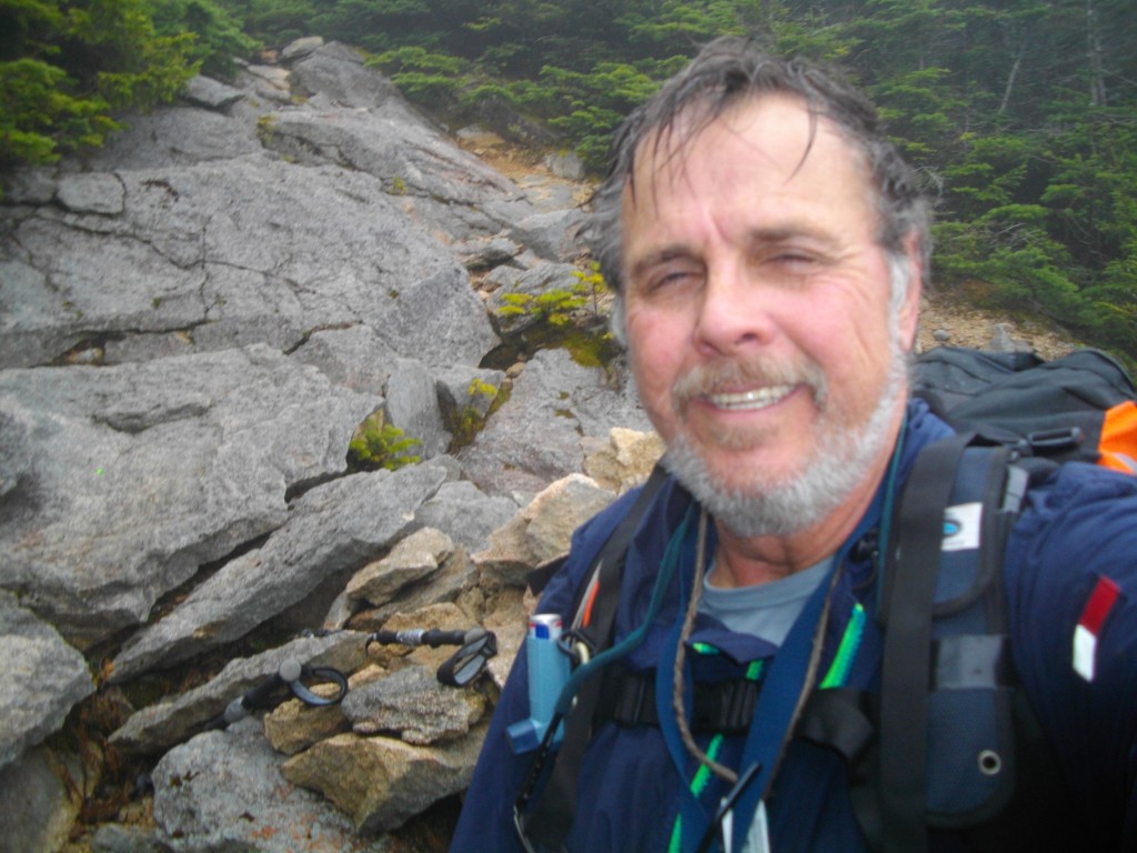
Self portrait summit pic.


Carrigain marker

Interesting trunk


Ice sculpture - penguin?


Trail Map (from AMC guide-on-line):


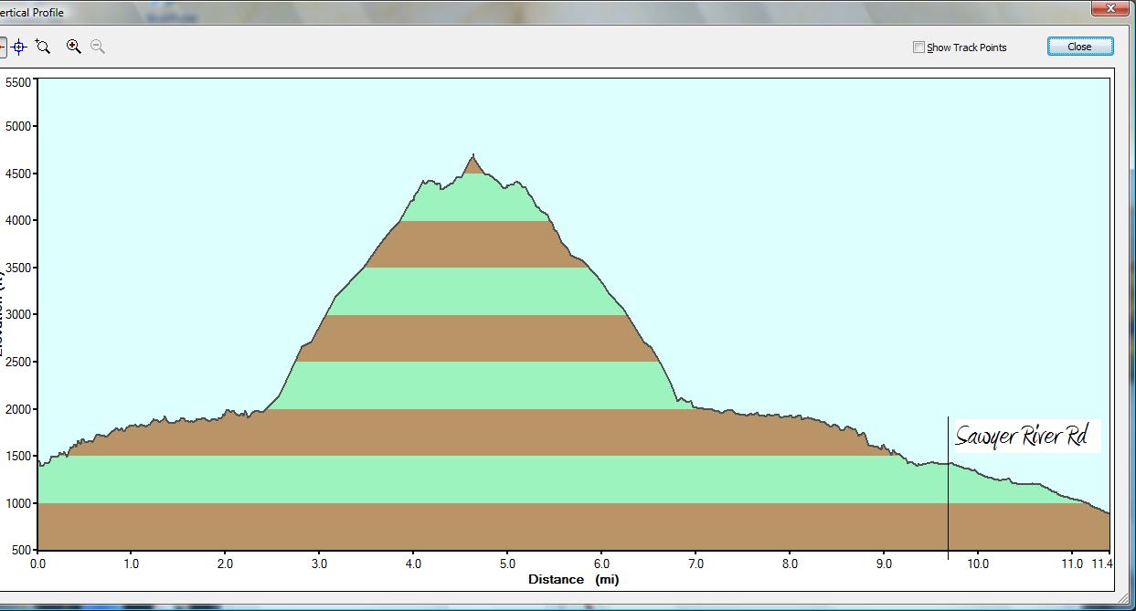
Hike Profile from my GPS:  I left the track on while I drove from the trail head to Rt 302 to show what I saved by doing this now.  Notice you can even see the tower excursion on the peak. 


GO BACK TO THE INDEX.  
GO TO THE NEXT HIKE
GO TO THE PREVIOUS HIKE


Monday, November 12, 2012

# 36-38; 3 Bonds Nov 11-12, 2012

21 mile overnight hike to three Bonds:

Nov 11,  2012: #36 Mt Bond (4698') & #37 Bondcliffs (4265')

Nov 12, 2012: #38 West Bond (4520)


Day  1 trails:  From Zealand trailhead,  Zealand trail and Twinway trail to Zealand Falls Hut,  Twinway to Zeacliff & Mt Guyot (4580’ but not one of the NH 48-4k’s),
Bondcliff trail to AMC Guyot campsite & Mt Bond (4698’ - #36) and Bondcliff (4265’ - #37), Bondcliff trail back to Mt Bond & Guyot Campsite.
11.9 miles (AMC ,  4801’ elevation gain,  2637’ elevation loss,  12 hours (0530-1730)
AMC book time:  08:19, My approximate moving time 11:00, Ratio to book time: 1.33 (typical for me)

Day2 trails:  From Guyot campsite, Bondcliff trail to West Bond spur, W. Bond spur to West Bond (4540’ - #38 )  and back. Bondcliff trail toTwinway trail,  Twinway trail to Mt Guyot to Zeacliff & Zealand Hut (I did not do the .1 mile Zealand Mt spur and retag the viewless Zealand Mtn peak) to Zealand trail, Zealand trail back to Zealand trail head.
9.08 miles (AMC), 1448’ elevation gain, 3612’ elevation loss 10 hours (0230-1230)
AMC book time 5:14, My approximate moving time 8:45, Ratio to book time: 1.6 (slow even for me ,but after checking the trace-back on my GPS I saw that I traveled much slower the several hours before sunrise)


Day 1:
The trails were a mixture of snow, slush and bare rocks.  Early in the day there was a light mist and melted snow dripping from the trees.  I only had on a light non-waterproof windbreaker and got fairly drenched before digging out a foul weather jacket to wear.  By the time I got to Guyot Mt it was sunny and it remained clear for the rest of the hike. The top of Guyot Mt is in the Alpine zone and is wide open with fantastic views.  I wish Kris and I had continued to it on our Mt Zealand hike.

I arrived at the campsite at 1300 and claimed a sleeping spot in the empty shelter and dropped off my sleeping bag,  pack, and most of my 30+ lbs of gear I was humping, just taking my light bug-out-bag for the hike on to Bond and Bondcliff.   Both Bond and Bondcliff are alos wide open with great 360 degree views of nothing but mountains with no signs of civilization.  My camera, which had been dropped too many times died shortly after Zeacliff.  I really wanted to get the classic picture standing on the edge of Bondcliff as I had seen on many other blogs.  I’m not sure I could have got the picture even with the camera working because no one was around and I would need at least a 1 minute delay.  I usually use the built in 10 second delay.  After taking a short sandwich break sitting on the edge of the hanging boulder I went further up and along the ridge until it started descending down the other side. As I walked back along the ridge another hiker showed up; Fred from Wayland Mass.  He graciously offered to take my picture on the cliffs with his camera and email them to me. (Included below).   after taking turn s posing on the hanging boulder, I headed back toward Mt Bond while Fred hung out at the cliffs for a while. Of course he soon caught up and passed me before I got back to Mt Bond. I hung out at Mt Bond for a while enjoying the views and watching the sunset. I really wish my camera was working to catch the great red sky sunset. “Red sky at night – Sailors delight” - YES!!  By the time I got off Mt Bond and back to the campsite there were 5 other hikers in the shelter.  Fred whom was already settled into his sleeping bag , and three guys that had hiked over the Twin Mountains.  I didn’t find out until late the next day that there was also a couple tenting on one of the tent platforms not in view of the shelter.   By this time I was exhausted and quickly heated up a cup of soup and crawled into my bag.

Description of the Guyot log shelter can be found at:  http://hikethewhites.com/guyot_shelter.html
It says that it is a 12 person shelter.  That would be 6 people on each of the two levels. That seems awfully tight. I would think 4 + 4 would be comfortable. And 5 + 5 to be maximum.   Now I see why most people prefer the tent platforms in the summer.


Day 2:

   The night wasn’t too cold (high 30’s maybe) and my 20 degree sleeping bag was fine without having to put on a heavier set of thermals.  It helped that one of the Twin Mt. hikers had brought a tarp to block off the entrance.  I woke up at 01:30 to make a head call and I saw that it was a perfectly clear night with excellent view of the stars with no wind.  I had planned on getting up about 4:00 and getting to West Bond in time to catch the sunrise from there, but, since I was up anyway, I decided to get an even earlier start.  Packing up, as quietly as I could I left the campsite at 02:30 AM.  Following the trail with a headlamp was easy with the thin coat of snow on the trails and the contrasting dark rocks poking through.  I stashed my ridiculously heavy pack at the spur head to the camp access trail and proceeded slowly to West Bond. The very peak of West Bond is open and by the star light I could see the surrounding mountains in silhouette.  The view of the stars from there was fantastic and I just laid on my back on the highest boulder enjoying the view for a while.  I could also see lights far to the North which I think may have been from the Mt Washington Hotel.  I shot an azimuth to check on my map later but haven’t done it yet.  I continued back to pick up my pack (ugh!) and continue on to Mt Guyot, planning to stop and have breakfast there while the sun came up. The sun was just starting to come up when I was on the peak of Guyot (not really a well defined peak) but the wind had picked up and I wouldn’t have been able to use my stove.  I went on down the trail further until I was out of the Alpine area and protected from the wind by small spruce trees but still with a partial view of the sunrise through the trees.   I had filled my canteen at the campsite the night before and while watching the sunrise I boiled water for my breakfast (oatmeal) and to fill water bottles. I did want to make coffee to but didn’t have as much water in the canteen as I thought.  The trail on the hike back to Zealand Falls Hut was more slush and dry trail and less snow than the day before but there were still sections of ice so I ended up putting on and taking off my micro-spikes several times.  Somewhere between the Mt Zealand spur head and Zeacliff, Fred caught up to me.  Of course he had got up at sunrise much later than me and ate breakfast himself before starting.  Yes, I am 1slowhiker.  He returned a flashlight that I had dropped along the trail during one of my micro-spike changes.  We hiked more or less together until Zeacliff (I can move along pretty good on level ground) but as soon as the trail started descending he quickly pulled away.  The hike back to Zealand Falls hut was uneventful except that I was out of drinkable water and was glad when I got to the water pump just north of the hut where there is a deep well with a hand pump that has excellent water.  They had already shut off the running water to the hut for the winter (supplied by the same well).  I stopped at the hut to sign the log and pick up a Zealand Falls souvenir pin for my grandson who had lost his from our stay there this summer (see July post) .  Down the final section of trail out I met a nice couple (close to my age) both carrying huge packs.  It turns out they had done the Bonds Sunday and spent the last two nights at the Guyot campsite on a tent platform. That’s a pretty good way to do it; hike in on the first day, hike the Bonds the second and hike out the third.  I may try to do that with my grandson this summer he would love the views from the Bonds.    Only, I hear it’s hard to even get a tent platform in the summer unless you arrive early.

In Summary this was a great hike. No section was particularly hard, just the fact that I was carry a 30+ lb pack made it a little tough on the shoulders and knees, but not as bad as I would have thought.   I read on someone’s site that the Bonds are the “Crown Jewels” of the Whites.  After being there I have to totally agree. This definitely goes on the repeat list after I finish the 48. Only 10 to go now.


Pictures:  As I said my camera died on me the first morning and I haven't been able to retreive the few pictures I did take. I do have a few pictures taken on  Bondcliff by another hiker who later emailed them to me . Thanks again ! Fred.


The classic photo op at Bondcliff 


Best seat in the house!


Since I don't have many pictures for this hike I decided to include the trail map downloads from the AMC guide on line and the traceback from my GPS. These are just screen prints so they don't have high resolution.

Day 1:

Day 2:


GPS dump (I don't have the topo maps loaded on the GPS)

Z05: Zealand Falls Hut,   Z06: Zealand Cliff,   Z13: Guyot campsite,  Z16: Mt Bond,  Z17: Bondcliff, Z15: West Bond.
GO BACK TO THE INDEX.  
GO TO THE NEXT HIKEGO TO THE PREVIOUS HIKE

Thursday, November 1, 2012

#34 & 35: TRIPYRAMIDS, Nov 1, 2012


#34 & #35  TRIPYRAMIDS, NOV, 1, 2012


#34 North Tripyramid (4160’), #35 Middle Tripyramid (4120).  
 
With Hurricane Sandy gone I was able to do a Birthday Hike after all. After reading Chris Dailey’s Tripyramid trip report I was tempted into attacking the Tripyramids.   After this hike, if asked what was my toughest hike so far?   “Slide on N. Trypyramid”.  What was my  most dangerous hike so far?   “Slide on N. Trypyramid”.  What was my favorite hike so far?  “Slide on N. Trypyramids”.

  This hike was  a loop from the Livemore Trailhead near Waterville Valley up the Livermore trail to the Tripyramids trail up a very steep rock slide to North Tripyramid to Middle Tripyramid to South Tripyramid (my # 35) down another less steep slide and back onto the Livemore trail then back to the trail head.  Total distance is 11.1 miles.  AMC book time is 7:10, my total time was about 9 hrs (08:45-17:45). No real long stops  many many 2-5 minute stops up the North Slide.

  There was 1 or 2 cars at the trailhead. When I got there .  Another hiker, Casey from Salem N.H.
showed up just after me.  The 1st 2.6 miles is an almost level back woods road hike to a junction with
the portion of the Tripyramid trail that I would return on from S. Tripyramid.   Casey had caught up to me at this point and of course soon disappeared from sight ahead of me as the trail got steeper  (my speed is inversely proportional to the grade).  The trail then splits again with the start of the Tripyramids trail to the right and the Livermore continuing left connecting to the Scaur Ridge trail that connects to the Pine Bend Brook trail which is an alternate longer but less steep approach to North Tripyramids.  The Tripyramid trail to the right crosses Avalanche River then runs parallel to the river until it reaches the base of the north slide .  Part of the trail was almost a river itself and the rest was difficult to follow, covered with leaves and no blazes in sight.  I’m not sure if I actually followed most of the trail but as long as I kept the river to my left within earshot, I knew I’d run into the slide part of the trail.  The slide started off fairly narrow, not too steep, but it kept getting wider and steeper.   According to AMC this slide is extremely steep and climbs 1200 feet over a distance of ½ a mile.   After about 10 minutes on the slide,  I ran into Casey working his way back down the slide. He said he was turning back and said something about it being insane or suicidal to continue and suggested I turn back too.   I of course continued and very slowly worked my way up.  I have to admit that this slide was extremely tough and challenging but taking one step and hand grab at a time and carefully planning my approach it was manageable.  However, with it being so steep I needed to stop almost every 50 feet of elevation for 2-3 minutes to catch my breath and let my heart rate settle down.   I found that the sides of the slide had small trees and roots for hand grabs but also were wetter and had a light coat of moss or lichens in spots making it more slippery. The center was drier making it less slippery but had less hand grabs and was more dangerous if you did slip because there wasn’t anything to grab or stop you.  Luckily I had worn my winter boots for this hike and had I better traction than my worn-down summer boots that I had worn on last week’s Kinsman hike.  It took me almost 2 hours to work my way up to the cairn at the top of this ½ mile slide.   I did have some pretty good views north and west during my many breaks but the sun never really broke through the hazy day. Just after the top of the slide, the trail continues up through the woods and meets Pine Brook trail just below the peak.  Just as I got to this junction I met Casey again coming up from the Pine Brook trail. He had gone all the way back to the Livemore /Tripyramid junction and came up the longer Scaur Ridge  and Pine Bend trails route and hiked almost 2 miles in the time it took me to a little over 0.5  The viewless N. Peak seemed less than an accomplishment then reaching the cairn at the top of the slide and I even forgot to take a picture. I hiked down the col between the north and middle peaks but of course fell behind again on short ascent to the Middle peak. The hike from the North to Middle to South Peak is fairly easy but was littered with a lot of blow-downs and small braches from Hurricane Sandy. The slide down the South Slide was fairly easy and uneventful.  It would have been an easier climb than the north slide but I would not want to have to gone down the steeper north Slide.  I found a hiking stick in the middle of the slide which I assume Belonged to Casey.   From the base of the north slide back to the junction with Livermore was also easy and also littered with damage from Sandy.  There were two fairly difficult river crossings on the way back. The first, which I could not identify on my map,  was a roaring river (see pics) dumping into Slide Brook .  The second was Avalanche Brook just before the Livermore junction. This one was much calmer but I couldn’t figure out a good rock hopping route and ended up balancing my way across a fallen tree (see pics).   Once across it was an easy 2.6 mile fast walk back to my truck.   Casey, if somehow your reading this, email me if you want your hiking stick back (clementsmw@verizon.net)


Pictures:
My camera lens was smudged and foggy so many pictures did not come out. Many that I did keep are still blurry.

beginning of the north slide.


northern view from the slide, sun trying to clear

lower section had a lot of hand grabs.

This shot captures the steepness of this slide.

first blaze I saw all day

Western view from the slide

More of the slide before it widens

clouds trying to clear from Osceloa?

Looking up the endless slide

Waterville Valley slopes
Cairn half way up

Slabs on side of upper part of slide

Many stops to catch my breath and take pictures.


The end is in sight
Finally at the top of the slide -
 I was clean shaven when I started up it -lol

foggy short hike from the slide to the peak


Junction with Pine brook trail where I met Casey again.
No views from N. Pyramid

Middle Pyramid Peak (#35)

Hurricane Sandy debri

more trail obstacles from Sandy
in col between M. and S. peaks

Tiny cairn at S. Tripyramid

Looking down the South Slide


weather trying to clear again


Almost a view to southeast from South Slide.
 
Looking back up the south slide.

Waterville slopes bareley visible to the right


Not really clear but I did avoid any rain.


From Sandy?

Many step overs.
Many branched falls.  The hardest to get through.

Obstacle course or hurdles.

Road Block !

First hard crossing

I'm not going across that tree.

This is where I crossed. Not too bad, but rocks where slippery.

Sandy or Irene?

This is tree I used to cross Avalance River

Could have actually waded that one.

Back at the trail head - just after dusk.


GO BACK TO THE INDEX.  
GO TO THE NEXT HIKE
GO TO THE PREVIOUS HIKE