Saddleback & Saddleback Horn ME 5/14/13
Maine Saddleback (4120') and Saddleback Horn (4041)
GO TO Maine/VermontHikes
GO TO New Hampshire Hikes.
My first Maine 4000 footer. Since I completed the New Hampshire 4k's in March I've been trying to decide what to do next. I had been ruling out the New England 4 thousand footer list (14 more in Maine, 5 in VT.) because some of the Maine peaks are just so far away (the Katahdins in Baxter Sate park are 400 miles from me). But, I have also recently retired and will stay at least semi retired. So, why not go for the full New England list and take 2-3 days to do a mountain or two for the longer ones if I have to).
I didn’t have a lot of info on these peaks because
my usual reference (AMC White Mountain trail guide on-line) only included New Hampshire.
I do have the AMC Maine mountains trail guide on order but it hadn’t arrived
yet. There are two typical options for doing these two peaks. 1) Start on the Appalachian
Trail (AT) from Rt. 4 and follow it to both peaks and return (about 14 miles I think)
or go up the saddle back ski slope (~7.5).
The AT route comes highly recommended, but I would have to do it as an
overnight back pack, so I chose the shorter ski slope route.
Trip Report:
Left home
(RI) at 1730 on Tuesday and arrived at Saddle back ski area at ~ 2330 (6 hrs).
Per Google it is suppose to be a bit less than a 5 hr drive. My added time is
due to traffic through Boston and a short stop in S. Portland to trying
to find an ME trail map.
My older car GPS kept trying to send me onto back dirt roads near the end of the trip. One ended up\ having signs that basically said the owner would shoot to kill any trespassers, the second lead me to a beat up old bridge that I'm sure would not take the weight of any car. I ended up ignoring the GPS and continued on the last paved road until there was a sign for Saddleback Mt. So, if you are planning to go to Saddleback do not take any dirt roads your GPS may recommend. Also, I expected that Saddleback, like NH ski areas, would have a built up area with resteraunts, fast food, & motels for skiers and tourist. Wrong! There is nothing around it except for one combination ski and fishing shop. I'm glad I brought my camping stove and sleeping bag
I slept in
the back of my truck in the Skiing parking lot, got up at ~0500, had a tail gate breakfast
of scrambled eggs and bacon (dehydrated) and started hiking at the base of the
ski slope at ~ 0630.
Note on the following pictures the time stamps are 1 hr
early.
 Most of the the slope was still covered with large areas of well packed man-made snow
a bit slippery to walk on until I put on my spikes. You could walk along the sides with no snow but it was pretty muddy.


This is what that section of trail looked like - It wasn't a trail at all, just a mini forest of dwarf spruce. What I finally realized was that the track I downloaded must have been from the winter when there was 3 or more feet of snow covering the brush. Rather than turn back, I slogged my way through the brush getting covered in rime ice and scratched by the spruce as I went (BTW I was wearing shorts).


Near the top there is a semi-circle wind barrier of rocks. I tucked in here out of the wind to take a short break and check in at home, surprisingly I actually got cell phone service from here.


 Back at saddleback with almost no wind now. Warm (50?) and sunny now. Took a long lunch break and enjoyed the views.


 \
\


(The link may not work and you may have to type or cut&paste it into your email)

Skiing lodge looking back from the slope 0530
a bit slippery to walk on until I put on my spikes. You could walk along the sides with no snow but it was pretty muddy.

The forecast for this day all week had been calm
with a high of 40 degrees and mostly sunny, (perfect hiking forecast). But,
just before I left RI it changed to partly sunny, windy and a chance of morning
sprinkles just before I left RI. But at that point momentum had taken control.
At first the sun was out but dark clouds approached from other Mts as I went up
the slopes. Thankfully the rain never did come but the wind did.


It took about two hours to get to the top of the ski area. The GPS track that I had downloaded had two routes up to Saddleback from here. One would have been just to the right of the tower on the right side of the picture, the other continued between the top of the lift and the building in the picture then part way down another slope and to the right. I unfortunatley chose to take the later route. ---

looking down one of the steeper ski trails to the left of my path.

from here the GPS track had me take a sharp right up the mt.

This is what that section of trail looked like - It wasn't a trail at all, just a mini forest of dwarf spruce. What I finally realized was that the track I downloaded must have been from the winter when there was 3 or more feet of snow covering the brush. Rather than turn back, I slogged my way through the brush getting covered in rime ice and scratched by the spruce as I went (BTW I was wearing shorts).
Almost to the peak,the wind really started picking up, bringing
the wind chill temp way down below zero. My face and ears where starting to
freeze and I then realized I hadn’t brought any winter head gear. No balaclava,
no face mask, not even a stocking cap.
I did, however bring a set of teck-wick
thermals, so I took out the thermal pants and coiled the legs around my head ,ears
and neck then put on a wind shell over the fleece jacket I was wearing. This worked out pretty good. (“adapt,
improvise, overcome!”):

Saddleback summit. A lot colder than you would expect for May.


Near the top there is a semi-circle wind barrier of rocks. I tucked in here out of the wind to take a short break and check in at home, surprisingly I actually got cell phone service from here.
At the peak I picked up the Appalachian Trail that comes up
from the west and goes over both Saddleback and The Horn. This section of the
AT is really easy to follow (at least when there is no snow on it) because the
white blazes on the rocks seem to be every twenty feet. Somebody must have humped
up lots of cans of paint.

a view of the AT going over to The Horn

Still patches of snow on some of the trail. These are called mono-rails, they are sections of hard packed snow that melts slower than the surrounding unpacked snow and leaves
a narrow "mono-rail" of snow.

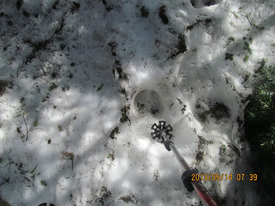
moose tracks on the trail


This steel ladder is strange. I've seen other ladders (steel
and wood) on really steep sections of trail but this one is not located at a particularly
hard scramble. In fact I didn’t trust this ladder and scrambled up to its left.

view of a wind farm - not that clear ( I think this is in Roxbury Me)

Moose shit. Lots of Moose skat on the trail. Even at the two peaks.
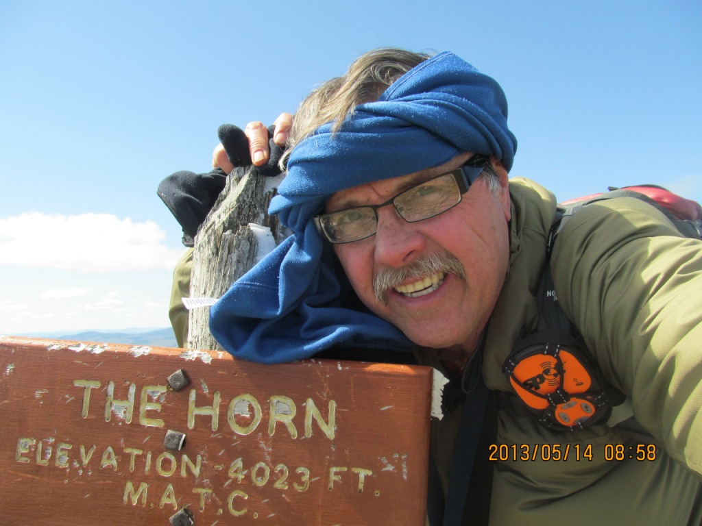
Summit pic for The Horn
Not nearly as much wind or cold as saddleback was.
The following are some views from The Horn:


Looking back down the AT on my way back to Saddleback. These two peaks are the type where you have to climb 3 to get 2, because there is no other way back,.


This time I took the actual trail down to the top of the ski lift
This is from the AT going west. The pole (without signs) marks the trail junction. Straight continues on the AT to Rt 4, sharp right is a trail to the top of the ski slopes.

A cool looking rain pool at the top of this nub.
Looks bigger than it is because of the dwarf trees.

Where the trail meets the Ski area.
 \
\
tiny snow bridge still left across a drainage strean

Going down I chose to follow the Ski lift trail. It was a bit hard on my knees, but it was a straight shot down and I was able to boot slide a lot of it.

back at the base of the lift

Back at my Truck 1330 (8 hr hike).
No one else on this trail today.
Thanks for viewing!
You can send comments, questions, etc to me at: 1slowhiker@gmail.com(The link may not work and you may have to type or cut&paste it into your email)
posted by 1SlowHiker @ 1:21 PM
0 Comments
![]()

0 Comments:
Post a Comment
Subscribe to Post Comments [Atom]
<< Home